ViewTube

ViewTube
Sign inSign upSubscriptions
Filters

Upload date

Type

Duration

Sort by

Features

Reset

1,467 results

NCSU GeoForAll Lab
About the Geospatial Modeling and Analysis Course at NCSU (GIS582/MEA582)

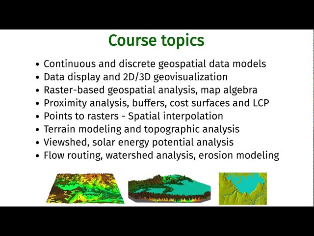
Introduction to and basic information about the Geospatial Modeling and Analysis course (GIS582/MEA582) at North Carolina ...

10:13
About the Geospatial Modeling and Analysis Course at NCSU (GIS582/MEA582)

2,352 views

7 years ago

Living Water Engineering
THEY LIED About Your Water! (This Map Proves It)

... Impact 12:05 - Geographical Inequalities 13:25 - Reccomendation/Conclusion A comprehensive geospatial analysis of drinking ...

15:12
THEY LIED About Your Water! (This Map Proves It)

4 views

8 months ago

FOSS4G SotM Oceania
FOSS4G 2025 | Evaluating LLMs as Intermediaries for FOSS4G CLI-based Geospatial Analysis

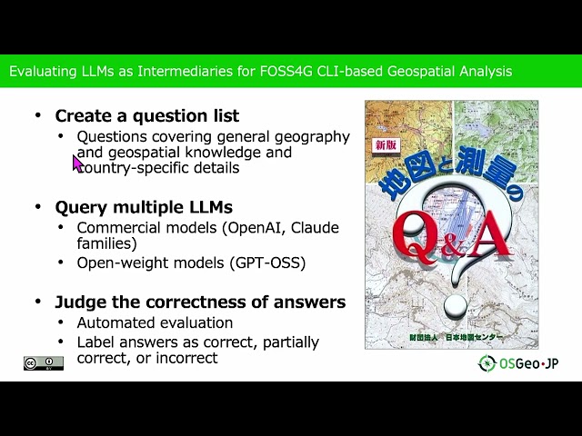
Presented by Nobusuke Iwasaki, Ayaka Onohara on 20 November 2025 09:05, at FOSS4G 2025 Auckland. Track: Lightning talk ...

5:12
FOSS4G 2025 | Evaluating LLMs as Intermediaries for FOSS4G CLI-based Geospatial Analysis

58 views

2 months ago

NCSU GeoForAll Lab
Geospatial modeling lecture (NCSU Geospatial Modeling and Analysis)

Lecture: Geospatial modeling and GIS-based modeling of landscape processes Lecturer: Helena Mitasova Course: NCSU ...

19:46
Geospatial modeling lecture (NCSU Geospatial Modeling and Analysis)

2,255 views

9 years ago

Dutton Institute
Intelligence and Geospatial Analysis in the Online Homeland Security Master’s Program at Penn State

Learn about Penn State's online Intelligence and Geospatial Analysis Option in the Master of Professional Studies in Homeland ...

5:52
Intelligence and Geospatial Analysis in the Online Homeland Security Master’s Program at Penn State

503 views

4 years ago

FOSS4G Perth
Diana Ong - LLM generated python for geospatial analysis in GDAL native environment

We advance geospatial data science through providing optimal dev ops for anyone to build geospatial models in a GDAL native ...

5:25
Diana Ong - LLM generated python for geospatial analysis in GDAL native environment

61 views

1 year ago

FOSS4G SotM Oceania
Mila Frerichs: How to create a fast and cost effective serverless geospatial analysis pipeline...

How to create a fast and cost effective serverless geospatial analysis pipeline using AWS (Lambda)

19:08
Mila Frerichs: How to create a fast and cost effective serverless geospatial analysis pipeline...

205 views

7 years ago

weecology
Geospatial Data in R - Extracting Raster Data at Points

... One of the common tasks that we want to perform in geospatial analysis is extracting data from rasters for use in our analyses.

9:58
Geospatial Data in R - Extracting Raster Data at Points

11,994 views

5 years ago

Geoinformatics
Geospatial Data Modelling

A overview of Geospatial Data Modelling including Conceptual models (ontologies) Digital representation models Analysis ...

19:41
Geospatial Data Modelling

6,089 views

7 years ago

Daniel Arribas-Bel
Point Patterns - A Course on Geographic Data Science

Block H of the Geographic Data Science course - "Points" More materials related to the content in this video are available at: ...

11:10
Point Patterns - A Course on Geographic Data Science

407 views

4 years ago

PyCon Israel
telluric: interactive manipulation of Geospatial data - Guy Doulberg - PyCon Israel 2018

telluric: interactive manipulation of Geospatial data with Jupyter and Python telluric library is an open source library developed by ...

19:34
telluric: interactive manipulation of Geospatial data - Guy Doulberg - PyCon Israel 2018

272 views

7 years ago

Sean Anderson
Campus Building Mapping in 3D

Here we run through a few things about our first effort to map campus buildings as 3D objects, using our Field Maps app, Open ...

18:26
Campus Building Mapping in 3D

219 views

1 year ago

weecology
Geospatial Data in R - Introduction to Raster Data

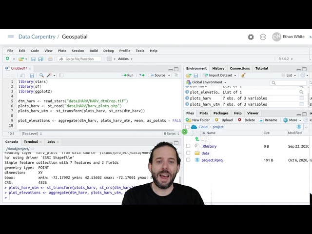
Data: https://datacarpentry.org/semester-biology/data/neon-geospatial-data.zip Full lessons (including multiple videos and ...

13:09
Geospatial Data in R - Introduction to Raster Data

26,002 views

5 years ago

Roel Van de Paar
GIS: GIS and natural disasters - examples of geo-visualizations and geospatial analysis

https://amzn.to/4aLHbLD You're literally one click away from a better setup — grab it now! As an Amazon Associate I earn ...

7:51
GIS: GIS and natural disasters - examples of geo-visualizations and geospatial analysis

23 views

4 years ago

TALE: The Archaeology Lecture E-library
Cracking the code of the cups: geospatial analysis of Scottish cup and ring marks

Emily Pickering, Gabriel Schussler Today, there is emerging consensus among academics regarding the significance of cup and ...

18:40
Cracking the code of the cups: geospatial analysis of Scottish cup and ring marks

769 views

1 year ago

Electromagnetic Field
A country you can't put in a box. - EMF2024

https://media.ccc.de/v/emf2024-96-a-country-you-cant-put-in-a-box A talk about the difficulties of geospatial analysis when the ...

15:46
A country you can't put in a box. - EMF2024

154 views

1 year ago

TALE: The Archaeology Lecture E-library
Free and open source geospatial software for re-using archaeology open data

... the presentation will focus on state-of-the-art WebGL map viewers and cloud-based solutions for performing geospatial analysis ...

17:50
Free and open source geospatial software for re-using archaeology open data

711 views

6 years ago

FOSS4G
FOSS4GE 2024 | Crossing the bridge from research to operational. FOSS based geo-knowledge ...

For geospatial enthusiasts, working with data, debugging code, running geospatial algorithms, making maps and then more maps ...

5:35
FOSS4GE 2024 | Crossing the bridge from research to operational. FOSS based geo-knowledge ...

62 views

1 year ago

iMooX at
M3 1.2 Geospatial Tools & Analysis for Landscape and Cultural Heritage | iMooX.at

This is a video of the course "Risk Management for Cultural Heritage" on https://imoox.at/course/RMCH The Risk Management for ...

8:46
M3 1.2 Geospatial Tools & Analysis for Landscape and Cultural Heritage | iMooX.at

40 views

1 year ago

weecology
Geospatial Data in R - Introduction to Vector Data
15:02
Geospatial Data in R - Introduction to Vector Data

6,504 views

5 years ago