ViewTube

ViewTube
Sign inSign upSubscriptions
Filters

Upload date

Type

Duration

Sort by

Features

Reset

1,486 results

Scott Redgate
What is GEO (Generative Engine Optimization)?

The era of the "10 blue links" is changing. Are you worried that AI tools like ChatGPT and Gemini are making your website ...

5:49
What is GEO (Generative Engine Optimization)?

183 views

11 days ago

Hallam's Echo Chamber
No More Point Deform! Better Deformation Methods | Houdini Tutorial

Download the HIP file: https://github.com/MysteryPancake/Houdini-Fun/blob/main/README.md#no-more-point-deform Momme ...

12:51
No More Point Deform! Better Deformation Methods | Houdini Tutorial

6,905 views

3 weeks ago

aruntastic
What is GEO? The Biggest Change to Search in 25 Years

... for Next Video: New Study - ChatGPT Recommends Just 1.2% of Businesses https://youtu.be/SHZXUJ9bOO4 Full GEO Tutorial ...

16:59
What is GEO? The Biggest Change to Search in 25 Years

23 views

11 days ago

Geomatics Engineer
Create & Edit Spatial Data Online (No Software Needed!) | GeoJSON.io Tutorial

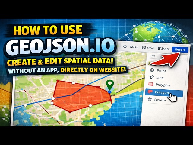
Learn how to create and edit spatial data directly in your browser using GeoJSON.io — a powerful, free, and open-source tool for ...

8:31
Create & Edit Spatial Data Online (No Software Needed!) | GeoJSON.io Tutorial

130 views

3 weeks ago

Sunny Israni
How to Audit Your Website for AI Search with Claude Cowork (GEO Tutorial)

AI is quietly becoming the new front door to the internet. People aren't just Googling anymore — they're asking ChatGPT, Claude, ...

18:49
How to Audit Your Website for AI Search with Claude Cowork (GEO Tutorial)

289 views

3 weeks ago

The Map Guide
How to Geo reference a Map in ArcGIS | Step-by-Step Tutorial for Beginners.

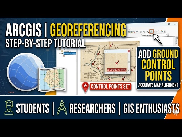
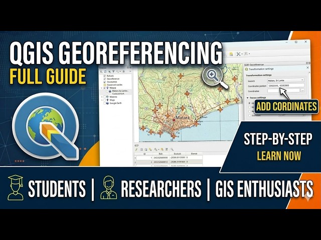
Welcome to The Map Guide! n this comprehensive tutorial, we walk you through the essential process of Geo referencing a ...

4:17
How to Geo reference a Map in ArcGIS | Step-by-Step Tutorial for Beginners.

66 views

2 weeks ago

iAspirant
World's Important Straits for UPSC Mapping | Strait of Hormuz, Gibraltar, Malacca  #geography

Master World's Important Straits for UPSC 2026. Detailed Mapping of Malacca, Hormuz, Bab-el-Mandeb & more for GS ...

7:13
World's Important Straits for UPSC Mapping | Strait of Hormuz, Gibraltar, Malacca #geography

40 views

3 weeks ago

John Okello
How to Convert Features to Points, Lines and Polygons in ArcMap (ArcGIS Tutorial)

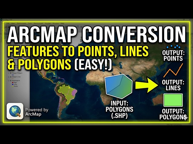
Learn exactly how to convert features to points, lines, and polygons in ArcMap using simple ArcGIS tools. Whether you need to ...

11:05
How to Convert Features to Points, Lines and Polygons in ArcMap (ArcGIS Tutorial)

138 views

3 weeks ago

Study with Sudhir
The Map Marking Quiz - ICSE Class 10 Geography #GeographywithSudhirSir

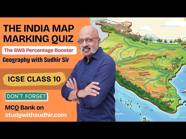
Don't Miss to test yourself on 400 MCQs and Reasoning Questions for Geography Exam on studywithsudhir.com website.

13:46
The Map Marking Quiz - ICSE Class 10 Geography #GeographywithSudhirSir

16,508 views

4 weeks ago

Senor Gallagher
New Geo Constructions day 1

... that were available at that time At one point they only had a tool capable of making a straight line and one capable of uh making ...

10:51
New Geo Constructions day 1

0 views

5 days ago

Cocajola
Do This Now To Deal BILLIONS Of Damage In Sailor Piece! - How To Deal More Damage Sailor Piece!

DO THIS NOW To Deal BILLIONS Of Damage In Sailor Piece! - How To Deal More Damage FAST (Best Damage Guide) In this ...

8:10
Do This Now To Deal BILLIONS Of Damage In Sailor Piece! - How To Deal More Damage Sailor Piece!

41,579 views

12 days ago

Amy Eller
Geo 10.7
19:27
Geo 10.7

6 views

4 weeks ago

Learn GIS - Tutorial Channel
Lesson 17: How to Import Points from Excel to QGIS (Step-by-Step Tutorial for Beginners)

Learn how to import points from Excel to QGIS in this step-by-step tutorial designed for beginners and GIS learners. In this video ...

7:46
Lesson 17: How to Import Points from Excel to QGIS (Step-by-Step Tutorial for Beginners)

10 views

3 weeks ago

KRISTEN TATUM
25-26 Adv Geo Solving with Radians
14:52
25-26 Adv Geo Solving with Radians

104 views

4 days ago

Vaibhav Sisinty
Anthropic's Claude Skills 2.0 Just Made Every AI Workflow Tool Obsolete (Complete Mastery)

Join our WhatsApp Community Get the latest AI updates, tips, and insights straight to your inbox: https://link.stayingahead.ai/YT7 ...

9:39
Anthropic's Claude Skills 2.0 Just Made Every AI Workflow Tool Obsolete (Complete Mastery)

98,372 views

3 weeks ago

DSPVerse_TheAllrounder
Geo-Referencing using Q-GIS || Map Creation ||

Georeferencing in QGIS (typically using the Georeferencer tool under the Raster or Layer menu) assigns real-world coordinates to ...

14:34
Geo-Referencing using Q-GIS || Map Creation ||

255 views

3 weeks ago

The Map Guide
QGIS Georeferencing Full Guide: Step by Step

Welcome to The Map Guide! In this video, we dive into one of the most essential skills in Geographic Information Systems (GIS): ...

7:17
QGIS Georeferencing Full Guide: Step by Step

58 views

3 weeks ago

sudgylacmoe
Rotating by Arbitrary Angles - From Zero to Geo 3.7

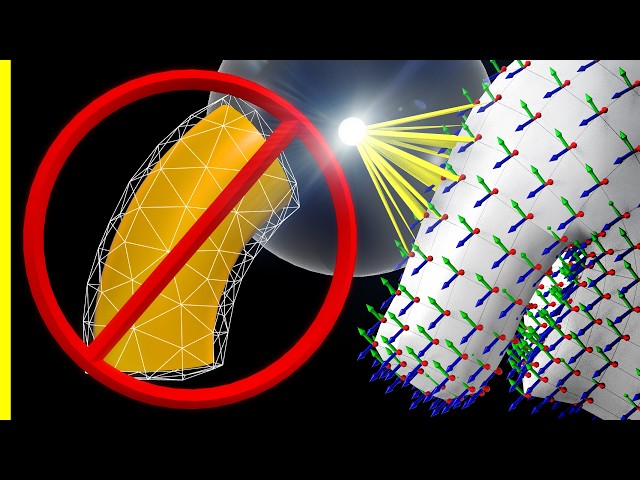
While we have previously covered how to rotate vectors using rotors, building rotors can be a bit tedious. Is there any shortcut to ...

10:34
Rotating by Arbitrary Angles - From Zero to Geo 3.7

2,826 views

5 days ago

GeoAnalysis Academy
QGIS Learning 014: How to Get Latitude & Longitude (Decimal Degrees) in QGIS

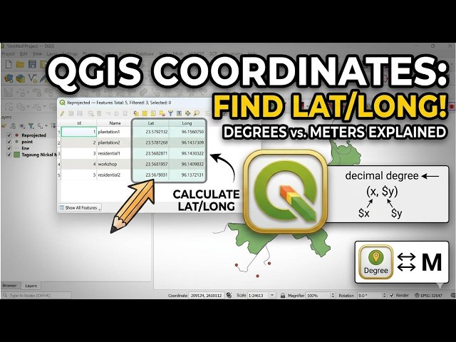
Struggling to find accurate latitude and longitude in QGIS? Or confused about Geographic vs Projected Coordinate Systems?

11:10
QGIS Learning 014: How to Get Latitude & Longitude (Decimal Degrees) in QGIS

4 views

10 days ago

STORILO
How a Compass Always Points North | The Science Explained

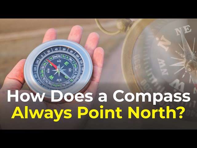
How a Compass Always Points North | The Science Explained Have you ever wondered how a Compass always seems to point ...

5:16
How a Compass Always Points North | The Science Explained

5 views

12 days ago