Upload date
All time
Last hour
Today
This week
This month
This year
Type
All
Video
Channel
Playlist
Movie
Duration
Short (< 4 minutes)
Medium (4-20 minutes)
Long (> 20 minutes)
Sort by
Relevance
Rating
View count
Features
HD
Subtitles/CC
Creative Commons
3D
Live
4K
360°
VR180
HDR
42 results
If you're still using shapefiles in ArcGIS Pro… you might be limiting your GIS projects without realizing it. In this beginner-friendly ...
76 views
5 days ago
How to Download DEM Data from OpenTopography and Visualize in ArcMap In this practical GIS tutorial, I demonstrate how to ...
0 views
4 days ago
14 views
GISRS-1 How to Create a Study Area Map Shapefile | Step-by-Step Tutorial (Beginner to Pro) | Episode 11 | ArcGIS In this ...
72 views
6 days ago
គ្រប់គ្នាដែលបានចូល View Like & Subscribe គឺបានជួយលើកទឹកចិត្ត ...
10 views
Learn how to perform georeferencing in ArcGIS with this complete step-by-step tutorial in GIS & Remote Sensing. This video ...
31 views
Want to add your own location data to ArcMap for mapping and analysis? In this step-by-step tutorial, we show you how to import ...
How to Add KML/KMZ File in ArcGIS | Save KM/KMZ File in Google Earh Pro Learn how to Import KML/KMZ in ArcGIS step-by-step ...
33 views
GISRS-1 How to Georeference an Image in ArcMap PRO | ArcGIS Pro Step-by-Step Tutorial [EPISODES - 8] Follow Me Online ...
34 views
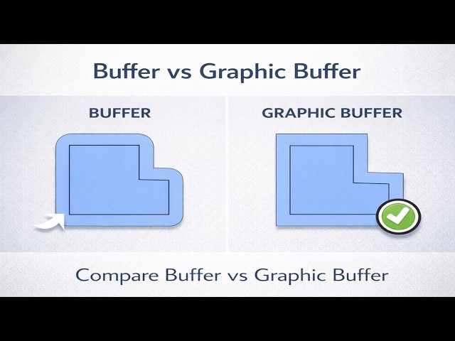
In this video, we explore the key differences between Buffer and Graphic Buffer in ArcGIS Pro, and why choosing the correct tool ...
41 views
2 days ago
Visit https://riobamwitagis.sevalla.page for any thematic map. In this tutorial, I demonstrate how to georeference a raster in ArcMap ...
17 views
1 day ago
24 views
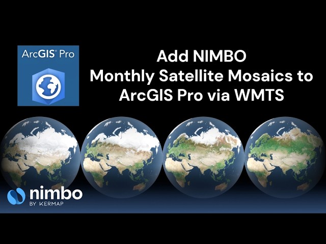
In this tutorial, we show how to integrate Nimbo satellite mosaics into ArcGIS Pro using a WMTS connection. You will learn how to: ...
12 views
Are you looking to download high-quality satellite imagery from Google Earth for your GIS projects? In this step-by-step tutorial, we ...
9 views
arcgistutorial #arcmap #arcgispro Welcome to ROY GIS ACADEMY This ArcGIS ArcMap complete course is designed for ...
How to Become a Google Earth Engine Expert? Join Our Online Training Program! Our community of geospatial learners is ...
11 hours ago
ArcGIS এ Raster to Vector ডেটা ইম্পোর্ট/ ইনপুট কিভাবে দিবেন? GIS শেখার শুরুতে ...
4 views
Global map of land use/land cover (LULC) derived from ESA Sentinel-2 imagery at 10m resolution. Each year is generated with ...
8 views
Thanks for watching! Support the channel by buying me a coffee ☕: https://buymeacoffee.com/gisintelugu Please Like, ...
In this step-by-step ArcGIS tutorial, learn how to automatically create polygons from GPS point data using powerful geoprocessing ...
35 views
13 hours ago


![How to Georeference an Image in ArcMap PRO | ArcGIS Pro Step-by-Step Tutorial[EPISODES-8]@GISRS-1](/api/proxy/image?url=https%3A%2F%2Fi.ytimg.com%2Fvi%2FDMYEJJ-m5ZI%2Fsddefault.jpg)