Upload date
All time
Last hour
Today
This week
This month
This year
Type
All
Video
Channel
Playlist
Movie
Duration
Short (< 4 minutes)
Medium (4-20 minutes)
Long (> 20 minutes)
Sort by
Relevance
Rating
View count
Features
HD
Subtitles/CC
Creative Commons
3D
Live
4K
360°
VR180
HDR
8,541,351 results
What is the INSPIRE Directive? Through the Infrastructure for Spatial Information in the European Community (INSPIRE), the ...
89,051 views
10 years ago
Ready to move beyond desktop GIS? Step into the Spatial Lab: a global community for ambitious geospatial professionals who ...
15,241 views
1 year ago
What is GIS? https://gisgeography.com/what-is-gis/ US Maps - https://usmaps.com/ Esri Mapping Software - https://www.esri.com/ ...
273,673 views
2 years ago
What if we could use existing technologies to improve our ability to respond to emergencies and outbreaks? Geographical ...
36,576 views
Learn what spatial analysis means in GIS and mapping. Discover how geographic data, remote sensing, and spatial relationships ...
11,919 views
1 subscribers
This video will introduce you to: - Spatial Information and Geographic Information Systems (GIS) - How GIS is used at the ...
2,254 views
8 years ago
Welcome to my channel, EduMastermind! In today's video, we're delving into a fascinating topic that lies at the intersection of ...
272 views
An overview of the conceptual model for representing spatial information 0:00 Introduction 00:24 What is spatial Information.
390 views
5 years ago
Communication systems using space-time coding are extremely complex. But what happens if we change perspective?
279 views
3 years ago
What is the spatial industry? It's all around us. In your phone, GPS, construction plans. 80% of Australian government's decisions ...
735 views
14 years ago
14th Global Summit Oncology & Cancer 2019 - David Nguyen.
151 views
6 years ago
Open Day 2018 Spatial Information Stephan Winter.
173 views
7 years ago
The Municipal Spatial Information System (MSIS) is a tool which can be used by all interested parties to aid decision making and ...
366 views
Learn how Padre Dam Municipal Water District is gaining efficiencies in their planning and operations by leveraging real-time GIS ...
560 views
Link to this course: ...
11,623 views
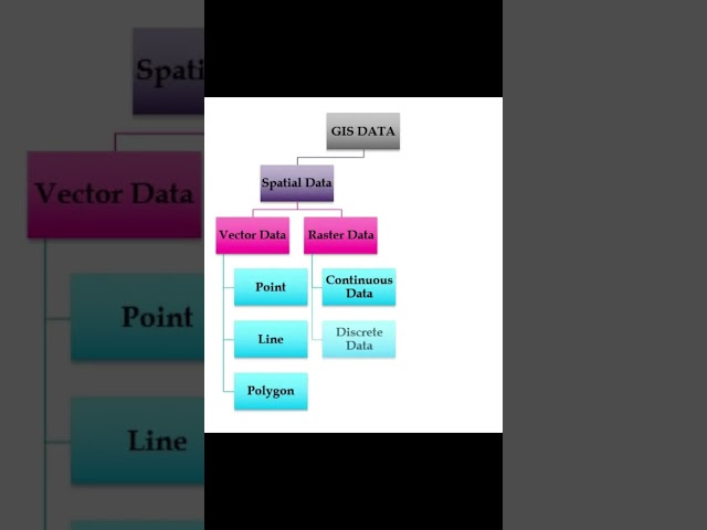
Learn about the diverse formats and structures used to represent spatial information, empowering you to make sense of ...
52,543 views
Total Geo-spatial Information Solutions (PTY) Ltd.
514 views


![Methods for Quantifying Hidden Spatial Information in Tumor Architecture [25 min]](/api/proxy/image?url=https%3A%2F%2Fi.ytimg.com%2Fvi%2FY6fC9gGTj6k%2Fsddefault.jpg)

![The Municipal Spatial Information System [subtitles ENG]](/api/proxy/image?url=https%3A%2F%2Fi.ytimg.com%2Fvi%2FEwqff-I7lx0%2Fsddefault.jpg)