ViewTube

ViewTube
Sign inSign upSubscriptions
Filters

Upload date

Type

Duration

Sort by

Features

Reset

3,449 results

FOSS4G
FOSS4GE 2024 | Geocint: Open Source Geospatial Data Processing Pipeline

For data-driven organizations, it is critical to have reliable ETL processes. As an open-source tool, Geocint can help organizations ...

24:58
FOSS4GE 2024 | Geocint: Open Source Geospatial Data Processing Pipeline

194 views

1 year ago

Ilya Zverev
Alexander Kmoch — Geospatial Platform for Forest Economy — Baltic GIT Conf 2023

"How we built a fast geospatial data analysis and reporting platform for the new forest economy" Slides and more info: ...

28:55
Alexander Kmoch — Geospatial Platform for Forest Economy — Baltic GIT Conf 2023

36 views

2 years ago

Northeast Big Data Innovation Hub
Geospatial Analysis Flashcard #4: What is Geospatial Data Processing?

Learn about Geospatial Analysis with the National Student Data Corps! Why is geospatial data processing important? What are ...

2:12
Geospatial Analysis Flashcard #4: What is Geospatial Data Processing?

411 views

2 years ago

FOSS4G
FOSS4GE 2024 | Scalable geospatial processing using dask and mapchete

Dask is a flexible parallel computing library that seamlessly integrates with popular Python data science tools. With its task graph ...

22:31
FOSS4GE 2024 | Scalable geospatial processing using dask and mapchete

93 views

1 year ago

PyCon Israel
telluric: interactive manipulation of Geospatial data - Guy Doulberg - PyCon Israel 2018

telluric: interactive manipulation of Geospatial data with Jupyter and Python telluric library is an open source library developed by ...

19:34
telluric: interactive manipulation of Geospatial data - Guy Doulberg - PyCon Israel 2018

272 views

7 years ago

FOSS4G
2019 - Geospatial data processing for image automatic analysis

https://media.ccc.de/v/bucharest-196-geospatial-data-processing-for-image-automatic-analysis Deep learning algorithms appear ...

24:18
2019 - Geospatial data processing for image automatic analysis

159 views

6 years ago

Hydro-Morphodynamics
Basic Geospatial Data Types

Get to know geospatial data types (basics) in the form of vector and raster data based on explanations from ...

15:17
Basic Geospatial Data Types

363 views

3 years ago

IEEE GRSS
Geospatial Big Data & Hyperspectral Tech Explorations | HDCRS Summer School 2023 | Day 1

On May 29, 2023, the Summer School organized by the HDCRS working group commenced with five lectures. The event started ...

3:55:13
Geospatial Big Data & Hyperspectral Tech Explorations | HDCRS Summer School 2023 | Day 1

363 views

2 years ago

INTERGEO TV
DRONE AND GEOSPATIAL DATA PROCESSING IN PRACTICE: REAL WORLD USE CASES AND BEST PRACTICES

GORKA ZARAUZ GeoCue (mdGroup), Business Development JAUME CAZORLA GeoCue Europe, Customer Success Manager ...

13:44
DRONE AND GEOSPATIAL DATA PROCESSING IN PRACTICE: REAL WORLD USE CASES AND BEST PRACTICES

71 views

2 years ago

Andrea Ross
21st Century Geospatial Data Processing

Azavea develops open source tools for geospatial data analysis. We are trying to enable the transformation of geographic data ...

8:58
21st Century Geospatial Data Processing

398 views

11 years ago

Engineering Community
Geospatial analytics (real project experience / tools) by Estiven Garcia

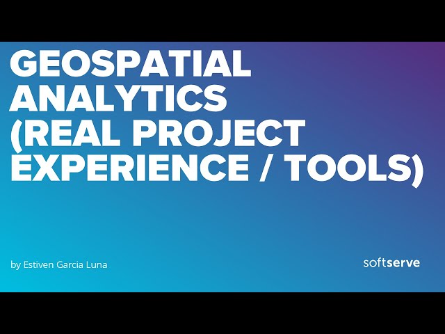
Agenda: Introduction to Geospatial Analytics Challenges in Geospatial Analytics Real Project Architecture Data Processing Tools ...

24:15
Geospatial analytics (real project experience / tools) by Estiven Garcia

70 views

1 year ago

BEEiLab
GeoSpatial Tutorial: What is GIS? GIS Applications Introduction to Geographic Information System

In this video, we will learn together about GIS technology by answering the below questions: What is GIS? How is GIS used?

3:31
GeoSpatial Tutorial: What is GIS? GIS Applications Introduction to Geographic Information System

748 views

2 years ago

FOSS4G
FOSS4G 2022 | Spatial data processing with workflow engines

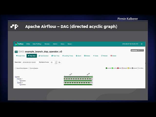
Workflow engines like Apache Airflow are commonly used in data engineering nowadays. They provide an infrastructure for ...

4:15
FOSS4G 2022 | Spatial data processing with workflow engines

51 views

1 year ago

Kartoza
GeoSpatialHosting - Hassle Free GIS Hosting

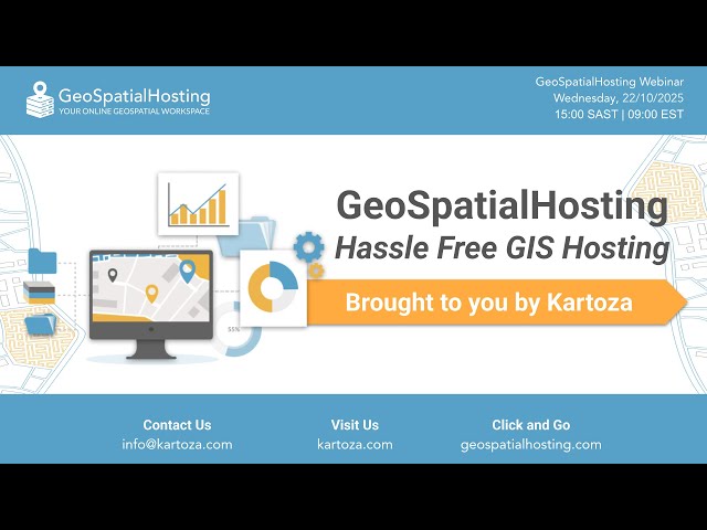
Discover Kartoza's newest open-source GIS hosting service — GeoSpatialHosting (GSH). 📽️ About the video: This recording is ...

17:40
GeoSpatialHosting - Hassle Free GIS Hosting

97 views

5 months ago

FOSS4G
FOSS4GE 2024 | Tile-based GIS

This short talk is about applying the concept of tiles to store geospatial information in a database and use it efficiently.

4:18
FOSS4GE 2024 | Tile-based GIS

70 views

1 year ago

FOSS4G
FOSS4G 2021 Using open source geospatial software to process, search, and analyze the data of....

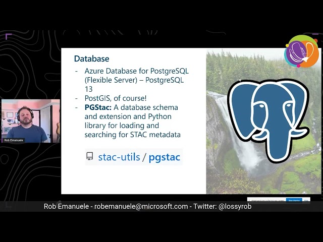
Using open source geospatial software to process, search, and analyze the data of our planet At Microsoft AI for Earth we're taking ...

30:56
FOSS4G 2021 Using open source geospatial software to process, search, and analyze the data of....

403 views

4 years ago

EuroPython Conference
Martin Christen - Processing Geodata using Python and Open Source Modules

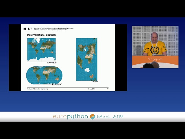
Processing Geodata using Python and Open Source Modules [EuroPython 2018 - Talk - 2018-07-27 - PyCharm [PyData]] ...

44:49
Martin Christen - Processing Geodata using Python and Open Source Modules

3,072 views

7 years ago

FOSS4G
FOSS4G 2022 | Serving Geospatial Data using Modern and Legacy Standards: a Case Study from the…

Serving Geospatial Data using Modern and Legacy Standards: a Case Study from the Urban Health Domain Serving Geospatial ...

19:29
FOSS4G 2022 | Serving Geospatial Data using Modern and Legacy Standards: a Case Study from the…

10 views

1 year ago

Australian Research Data Commons - ARDC
Geospatial Capabilities for the next decade - eResearch Australasia 2021 BoF

Recorded: 11 October 2021 Contributors: - Dr Sanjeev Kumar Srivastava - Professor Allison Kealy - Dr Lesley Wyborn - Dr ...

1:27:38
Geospatial Capabilities for the next decade - eResearch Australasia 2021 BoF

179 views

4 years ago

R Consortium
Analyzing Geospatial Data in R (Sherrie Xie)

Sherrie Xie, Post-doctoral research fellow at the University of Pennsylvania gave a workshop at the R/Medicine 2022 Virtual ...

2:01:43
Analyzing Geospatial Data in R (Sherrie Xie)

13,779 views

3 years ago

The ASF
Processing Geospatial Data at Scale with Python and Apache Sedona (incubating). - Paweł Kociński

Thank you to all of of our ApacheCon@Home 2021 sponsors, including: STRATEGIC --------------- Google PLATINUM ...

41:27
Processing Geospatial Data at Scale with Python and Apache Sedona (incubating). - Paweł Kociński

5,617 views

4 years ago

EuroPython Conference
Martin Christen - Geospatial Analysis using Python and JupyterHub

"Geospatial Analysis using Python and JupyterHub [EuroPython 2019 - Talk - 2019-07-10 - Singapore [PyData track] [Basel, CH] ...

30:06
Martin Christen - Geospatial Analysis using Python and JupyterHub

557 views

6 years ago

Andrea Ross
Real-time Raster Processing with GeoTrellis

The goal of the project is to transform user interaction with geospatial data by bringing the power of geospatial analysis to real ...

17:57
Real-time Raster Processing with GeoTrellis

741 views

11 years ago

UK Centre for Greening Finance and Investment
Our work: spatial finance

'Spatial Finance' is the integration of geospatial data and analysis into financial theory and practice. Our Spatial Finance Initiative ...

0:54
Our work: spatial finance

63 views

1 year ago

Geoinformatics
Geospatial Data Modelling

A overview of Geospatial Data Modelling including Conceptual models (ontologies) Digital representation models Analysis ...

19:41
Geospatial Data Modelling

6,095 views

7 years ago