ViewTube

ViewTube
Sign inSign upSubscriptions
Filters

Upload date

Type

Duration

Sort by

Features

Reset

50 results

AIMES
Using the ITRDB records as century-long benchmarks for land-surface models

Topic: Challenges in dealing with observations Jina Jeong (Vrije Universiteit Amsterdam) - Using the International Tree-Ring Data ...

13:34
Using the ITRDB records as century-long benchmarks for land-surface models

60 views

4 years ago

OpenGeoHub Foundation Official Channel
Giuseppe Amatulli: Hydrography90m pushing the boundaries of computational hydrology

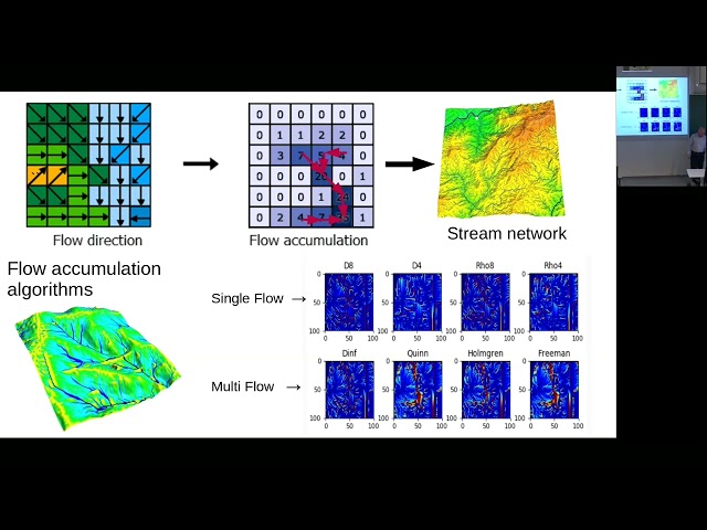
How to cite: Amatulli, G., Garcia Marquez, J., Sethi, T., Kiesel, J., Grigoropoulou, A., Üblacker, M. M., Shen, L. Q., and Domisch, ...

1:01:34
Giuseppe Amatulli: Hydrography90m pushing the boundaries of computational hydrology

435 views

2 years ago

Anna Petrášová
wxNviz_surface_vector.ogv

This GRASS GIS tutorial shows how to load raster and vector data into 3D view and set some of their properties.

1:46
wxNviz_surface_vector.ogv

3,127 views

14 years ago

the aleatoric learning channel
QuikSCAT

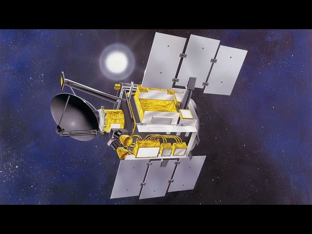
QuikSCAT: QuikSCAT far exceeded these design expectations and continued to operate for over a decade before a bearing ...

2:02
QuikSCAT

94 views

4 years ago

Stephen Sinclair
Siconos rockfall simulation

200 independent rocks falling down a slope, based on DEM data. Surface scattered with obstacles with a stochastic distribution.

0:20
Siconos rockfall simulation

179 views

8 years ago

CWU Geography
Creating a density surface in ArcGIS Pro

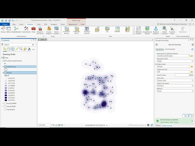
Dr. Nicholas Schuelke demonstrates how to use a kernel density function in ArcGIS Pro to convey a point pattern. Central ...

5:49
Creating a density surface in ArcGIS Pro

1,439 views

4 years ago

NASA Science
ScienceCasts: Measuring the Rising Seas

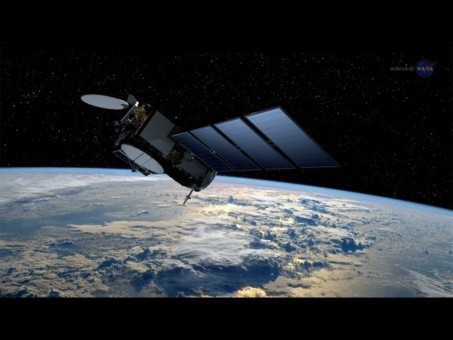
Visit http://science.nasa.gov/ for more. The Jason-3 satellite, launched on January 17, 2016, is allowing scientists to continue a ...

3:41
ScienceCasts: Measuring the Rising Seas

24,039 views

10 years ago

Universität Bern
Downscaling - from global weather reconstructions to local weather reconstructions

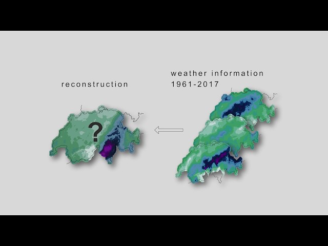
The video is part of an e-learning tool and describes methods to generate local weather reconstructions from global weather ...

4:15
Downscaling - from global weather reconstructions to local weather reconstructions

1,802 views

6 years ago

Roel Van de Paar
GIS: How to smooth the DTM?

GIS: How to smooth the DTM? Helpful? Please support me on Patreon: https://www.patreon.com/roelvandepaar With thanks ...

2:39
GIS: How to smooth the DTM?

87 views

4 years ago

STEM RTCL TV
An Improved Mono-Window Algorithm for Land Surface Temperature Retrieval from Landsat... | RTCL.TV

Keywords ### #Landsat8TIRSdata #landsurfacetemperature #thermalinfrared #monowindowalgorithm #splitwindowalgorithm ...

1:52
An Improved Mono-Window Algorithm for Land Surface Temperature Retrieval from Landsat... | RTCL.TV

12 views

1 year ago

Geoinformatics
Creating a Geospatial digital representation Model

Describing the Process of converting a geopolitical conceptual model to a digital representation 00:00 Introduction 01:15 ...

30:07
Creating a Geospatial digital representation Model

550 views

7 years ago

Geo-Plus
VL365 - Area measurement

Need precise material estimates? Learn how to calculate surface areas on sloped terrain, vertical facades, or flat foundations.

0:46
VL365 - Area measurement

47 views

7 months ago

Peter Schneider
Gis: Unable to map land surface temperature in QGIS from downloaded tiff

Unable to map land surface temperature in QGIS from downloaded tiff I hope you found a solution that worked for you :) The ...

2:56
Gis: Unable to map land surface temperature in QGIS from downloaded tiff

12 views

1 year ago

ICTP Earth System Physics
Data assimilation in hydrological sciences (Part I)

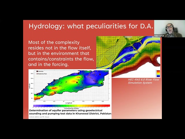
Joint ICTP-IUGG Workshop on Data Assimilation and Inverse Problems in Geophysical Sciences | (smr 3607) Speaker: Fabio ...

41:53
Data assimilation in hydrological sciences (Part I)

347 views

4 years ago

STEM RTCL TV
Land Surface Temperature Retrieval from Landsat 5, 7, and 8 over Rural Areas: Assessm... | RTCL.TV

Keywords ### #landsurfacetemperature(lst) #landsurfaceemissivity(lse) #performanceevaluation #monowindowalgorithm ...

0:51
Land Surface Temperature Retrieval from Landsat 5, 7, and 8 over Rural Areas: Assessm... | RTCL.TV

39 views

2 years ago

Geo-Plus
Discover the functionalities of VisionLidar - Advanced Point Cloud Processing and Analysis

Looking for an advanced point cloud processing and analysis software? Look no further than VisionLidar 2022! In this video, we'll ...

5:43
Discover the functionalities of VisionLidar - Advanced Point Cloud Processing and Analysis

696 views

2 years ago

Geoinformatics
Combining DSM and DTM data for urban surface water flow modelling

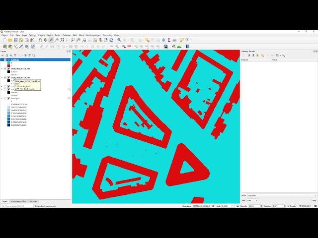
In this short video, I combine DSM and DTM data for urban surface water flow modelling. The video is the third of a series of four ...

7:37
Combining DSM and DTM data for urban surface water flow modelling

1,842 views

5 years ago

STEM RTCL TV
Towards learning universal, regional, and local hydrological behaviors via machine le... | RTCL.TV

Keywords ### #Memorynetworks #LongShortTerm #ShortTermMemory #rainfallrunoffmodeling #paperproposes ...

0:31
Towards learning universal, regional, and local hydrological behaviors via machine le... | RTCL.TV

25 views

2 years ago

STEM RTCL TV
Land Surface Temperature Retrieval from Landsat 5, 7, and 8 over Rural Areas: Assessm... | RTCL.TV

Keywords ### #landsurfacetemperature(lst) #landsurfaceemissivity(lse) #performanceevaluation #monowindowalgorithm ...

0:54
Land Surface Temperature Retrieval from Landsat 5, 7, and 8 over Rural Areas: Assessm... | RTCL.TV

35 views

2 years ago

Geo-Plus
Discover the right solution to work with LiDAR data.

Our LiDAR processing software is the most complete solution so far. Our LiDAR software process up to 25 billion points coming ...

2:30
Discover the right solution to work with LiDAR data.

623 views

8 years ago

Roel Van de Paar
GIS: Generating an image representing inland surface water using QGis and OSM data (2 Solutions!!)

GIS: Generating an image representing inland surface water using QGis and OSM data Helpful? Please support me on Patreon: ...

3:34
GIS: Generating an image representing inland surface water using QGis and OSM data (2 Solutions!!)

0 views

4 years ago

tv7.studio
Using ArcGIS Story Maps in information work

Українська версія трансляції: https://youtu.be/FYEXnI8RpX8 During the Strategic Communication Event 'The usage of Slavutych ...

1:09:11
Using ArcGIS Story Maps in information work

123 views

Streamed 4 years ago

L'ObservaTerre
The French seismological and geodetic network - RESIF-EPOS

The construction of RESIF - the French seismological and geodetic network - was launched in 2009 in an effort to develop, ...

4:09
The French seismological and geodetic network - RESIF-EPOS

158 views

6 years ago

STEM RTCL TV
Mapping daily evapotranspiration at field to continental scales using geostationary a... | RTCL.TV

Keywords ### #landsurfacetemperature #estimatingevapotranspiration #droughtconditions #LST #valuabletool ...

1:26
Mapping daily evapotranspiration at field to continental scales using geostationary a... | RTCL.TV

11 views

1 year ago

Marc Spiller
3 unlimited storage

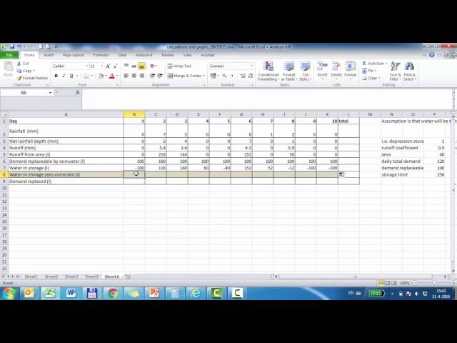
Guide for calculation of unlimited rainwater storage in excel with a constant demand.

6:06
3 unlimited storage

13 views

9 years ago