ViewTube

ViewTube
Sign inSign upSubscriptions
Filters

Upload date

Type

Duration

Sort by

Features

Reset

7,966 results

Roel Van de Paar
GIS: Creating travel time isochrones using ArcGIS Desktop?

... travel time isochrones using ArcGIS Desktop? Helpful? Please support me on Patreon: https://www.patreon.com/roelvandepaar ...

2:03
GIS: Creating travel time isochrones using ArcGIS Desktop?

197 views

4 years ago

Matt Myers
Network Drive Time Bands using Maptitude Part 2

Part Two of of creating network Drive Time Bands of Melbourne's Six Super Regional Shopping Center using Caliper Corp's ...

4:06
Network Drive Time Bands using Maptitude Part 2

260 views

13 years ago

Robson
Real-Time Travel Map from Rome to all European Capital Cities

This video shows the fastest routes from the centre of Rome to all other European capital cities, if they can be reached within 40 ...

10:00:54
Real-Time Travel Map from Rome to all European Capital Cities

227 views

5 years ago

Matt Myers
Network Drive Time Bands using Maptitude Part 1

Part One of creating network Drive Time Bands of Melbourne's Six Super Regional Shopping Center using Caliper Corp's ...

10:01
Network Drive Time Bands using Maptitude Part 1

561 views

13 years ago

Riccardo Klinger (Digital Geography)
quick QGIS 1: drivetime polygons in QGIS

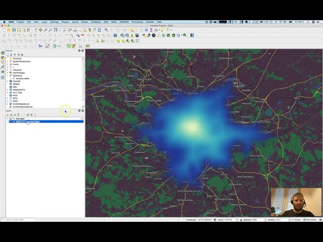
In this short tutorial you will learn how to calculate drivetime polygons inside QGIS using HQGIS, and apply a great visual style ...

2:48
quick QGIS 1: drivetime polygons in QGIS

2,443 views

5 years ago

Roel Van de Paar
GIS: Calculating drive time in QGIS (2 Solutions!!)

https://amzn.to/4aLHbLD You're literally one click away from a better setup — grab it now! As an Amazon Associate I earn ...

2:35
GIS: Calculating drive time in QGIS (2 Solutions!!)

14 views

4 years ago

Strive4impact
How to Calculate Driving Distance And Drive Time

http://www.ShowMeHowToDoThis.com Most Maps tools now let you calculate both drive time and driving distance. Here's where ...

2:47
How to Calculate Driving Distance And Drive Time

2,331 views

9 years ago

Roel Van de Paar
GIS: Creating drive time polygon around map point? (4 Solutions!!)

https://amzn.to/4aLHbLD You're literally one click away from a better setup — grab it now! As an Amazon Associate I earn ...

4:23
GIS: Creating drive time polygon around map point? (4 Solutions!!)

6 views

4 years ago

Roel Van de Paar
GIS: Creating Drive Time Polygons In ArcMap?

https://amzn.to/4aLHbLD You're literally one click away from a better setup — grab it now! As an Amazon Associate I earn ...

1:28
GIS: Creating Drive Time Polygons In ArcMap?

6 views

4 years ago

Roel Van de Paar
GIS: Creating Drive time analysis service area using ArcGIS Network Analyst?

https://amzn.to/4aLHbLD You're literally one click away from a better setup — grab it now! As an Amazon Associate I earn ...

1:43
GIS: Creating Drive time analysis service area using ArcGIS Network Analyst?

26 views

4 years ago

Geoinformatics
Using time as a measurement of distance in ArcMap

A introduction to the use of cost surface tools to calculate travel time.

14:56
Using time as a measurement of distance in ArcMap

10,052 views

10 years ago

Railways | Retro Tech | DIY
I Got Tired of Google Maps... So I Built My Own

Once everything worked, the app could calculate the true “cost” of any road by combining travel time with the time you'd need to ...

31:23
I Got Tired of Google Maps... So I Built My Own

112,529 views

3 months ago

Roel Van de Paar
GIS: Enabling DriveTime (Minutes) in Network Analyst Service Area Creation?

GIS: Enabling DriveTime (Minutes) in Network Analyst Service Area Creation? Helpful? Please support me on Patreon: ...

2:11
GIS: Enabling DriveTime (Minutes) in Network Analyst Service Area Creation?

4 views

4 years ago

GEO 2004
Travel Time Mapping Over Terrain Using Tobler Hiking Function and ArcGIS

How to perform raster based travel time mapping, using tobler's hiking function, and path distance tool of ArcGIS spatial analyst ...

6:14
Travel Time Mapping Over Terrain Using Tobler Hiking Function and ArcGIS

4,069 views

7 years ago

Roel Van de Paar
GIS: Creating drive time polygons using Open Source tools? (10 Solutions!!)

https://amzn.to/4aLHbLD You're literally one click away from a better setup — grab it now! As an Amazon Associate I earn ...

6:22
GIS: Creating drive time polygons using Open Source tools? (10 Solutions!!)

3 views

4 years ago

StopGame USA
Cities  Skylines One Time Map Testing First Person Drive Mode

Cities Skylines One Time Map Testing First Person Drive Mode check out our fashion partners https://fashionforwardlifestyle.com.

14:22
Cities Skylines One Time Map Testing First Person Drive Mode

29 views

3 years ago

Ryan Ludwin
Hand Drawn Map in google drive

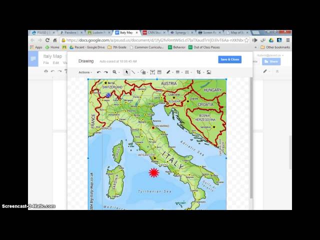
insert a drawing and trace a map, in google drive.

10:03
Hand Drawn Map in google drive

451 views

11 years ago

The Tech Girl
Apple Maps Tips & Tricks You Should Be Using in 2025

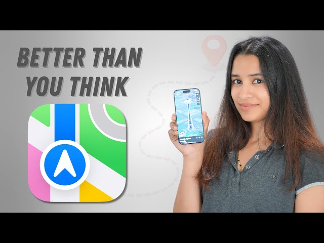
Think Apple Maps is still behind Google Maps? Think again! In this video, I'll show you 10 powerful Apple Maps features you ...

12:38
Apple Maps Tips & Tricks You Should Be Using in 2025

110,252 views

7 months ago

BlazerNG
BeamNG.drive basics for beginners

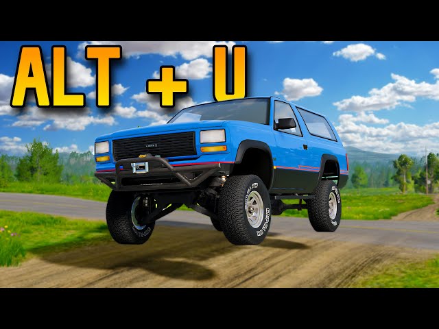
As we all know, starting out in BeamNG isn't easy. In this video, I'll show you a few tricks that might be useful for you in the ...

9:23
BeamNG.drive basics for beginners

237,643 views

1 year ago

Google Earth
Google Timelapse: Minneapolis - St Paul, Minnesota

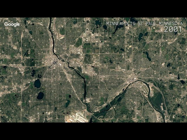
Timelapse is a global, zoomable video that lets you see how the Earth has changed over the past 32 years. Explore the world ...

0:13
Google Timelapse: Minneapolis - St Paul, Minnesota

14,733 views

9 years ago