Upload date
All time
Last hour
Today
This week
This month
This year
Type
All
Video
Channel
Playlist
Movie
Duration
Short (< 4 minutes)
Medium (4-20 minutes)
Long (> 20 minutes)
Sort by
Relevance
Rating
View count
Features
HD
Subtitles/CC
Creative Commons
3D
Live
4K
360°
VR180
HDR
173,364 results
Learn QGIS and Modern GIS in the Spatial Lab ➡️ https://forrest.nyc/spatial-lab/ ⬅️ Get ready to learn QGIS with this complete ...
516,265 views
2 years ago
Geospatial Information Systems (GIS) is a unique problem-solving technology with remarkable impact. In this video, visionary ...
139,282 views
1 year ago
In the subject of Geographic Information Systems (GIS), the vector and raster formats are two ways of representing real-world ...
34,505 views
This tutorial will show you how to import a DEM image into the ArcGis software. Please subscribe, like, and comment. احصل على ...
37,710 views
SAGA GIS, contour lines, DEM, digital elevation model, geographic information system, GIS tutorial, terrain analysis, mapping ...
247 views
6 months ago
Ready to move beyond desktop GIS? Step into the Spatial Lab: a global community for ambitious geospatial professionals who ...
71,065 views
This video is a very basic look at QGIS for Absolute Beginners. At times it is really fast ( I mean it, it is wicked fast), and you will ...
838,173 views
6 years ago
For many GIS professionals, SQL and databases can feel intimidating. They seem like tools for data engineers, not map makers.
9,859 views
5 months ago
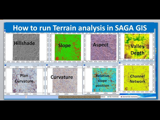
... SAGA GIS, terrain modeling, digital elevation model, GIS tutorial, topography analysis, geospatial analysis, landform analysis, ...
462 views
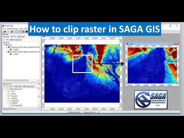
Buy me a coffee: https://buymeacoffee.com/geojay SAGA GIS, clip raster, GIS tutorial, geographic information system, raster ...
273 views
ArcGIS Field Maps is a mobile app that combines map viewing, data collection, and location tracking into a single app for easier ...
81,669 views
5 years ago
In this video from Esri UC 2025, Jess Altamira and Caitlin Marin demonstrate three new deep learning tools in ArcGIS that ...
11,737 views
Welcome to our comprehensive beginner's tutorial on ArcGIS! In this video, we'll walk you through the fundamentals of ...
13,483 views
3 years ago
Learn how to assign a coordinate system in ArcGIS for AutoCAD. Follow us on Social Media! Twitter: https://twitter.com/Esri ...
17,748 views
This video explains how to download the data for GIS Tutorial 1 from Canvas.
402 views
28,596 views
In architecture, engineering, and construction, location is everything. Every project begins with a place. To understand that place, ...
2,705 views
Buy me a coffee: https://buymeacoffee.com/geojay GRASS GIS, database creation, GIS tutorial, geographic information system, ...
243 views
SAGA GIS, add data to grid, GIS tutorial, geographic information system, data management, SAGA software, spatial analysis, ...
270 views
Learn GeoPandas and Modern GIS by joining the Spatial Lab ➡️ https://forrest.nyc/spatial-lab/ ⬅️ Looking to dive into ...
72,523 views