Upload date
All time
Last hour
Today
This week
This month
This year
Type
All
Video
Channel
Playlist
Movie
Duration
Short (< 4 minutes)
Medium (4-20 minutes)
Long (> 20 minutes)
Sort by
Relevance
Rating
View count
Features
HD
Subtitles/CC
Creative Commons
3D
Live
4K
360°
VR180
HDR
4,413,482 results
What is GIS? https://gisgeography.com/what-is-gis/ US Maps - https://usmaps.com/ Esri Mapping Software - https://www.esri.com/ ...
270,777 views
2 years ago
Take a look at this beginner tutorial and create your first map in QGIS. 0:00 Intro 0:43 Adding your first data 2:35 Connecting to ...
392,323 views
3 years ago
Geospatial Information Systems (GIS) is a unique problem-solving technology with remarkable impact. In this video, visionary ...
144,222 views
1 year ago
Learn QGIS and Modern GIS in the Spatial Lab ➡️ https://forrest.nyc/spatial-lab/ ⬅️ Get ready to learn QGIS with this complete ...
533,729 views
Ready to move beyond desktop GIS? Step into the Spatial Lab: a global community for ambitious geospatial professionals who ...
179,048 views
118,207 views
This 10 minute video describes how geographic information systems (GIS) are transforming our world. Particular emphasis is on ...
334,669 views
13 years ago
In the subject of Geographic Information Systems (GIS), the vector and raster formats are two ways of representing real-world ...
36,722 views
Ready to take your GIS skills to the next level in 2025? This video walks you through 5 exciting GIS project ideas that you can ...
11,959 views
Explore practical geospatial and GIS skills with courses and resources from GeoDelta Labs: https://www.geodeltalabs.com ...
1,953,840 views
5 years ago
What is GIS? In this beginner-friendly video, I explain what a Geographic Information System (GIS) is, how it works, and why it's ...
2,389 views
9 months ago
Explore the possibilities of mapping in ArcGIS Online. This video shows you how to get started with creating a map in Map Viewer.
98,536 views
For the complete video series Introduction to GIS I: Fundamentals and Mapping, see the following playlist: ...
53,857 views
8 years ago
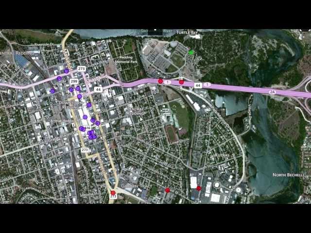
How to use GIS, Google Earth and Google Maps to get detailed information on property and land for your homestead, farm or ...
27,675 views
4 years ago
Armed with GIS, marine biologist Sylvia Earle and her team are better able to track the ocean's patterns. With 90% of the ocean ...
3,164 views
In this video we use QGIS and Blender GIS to import maps, heightmaps, and OSM data accurately into Blender. QGIS: ...
60,844 views


![What is GIS? | Beginner-Friendly Explanation [2025]](/api/proxy/image?url=https%3A%2F%2Fi.ytimg.com%2Fvi%2FfiIovJSBrVI%2Fsddefault.jpg)