ViewTube

ViewTube
Sign inSign upSubscriptions
Filters

Upload date

Type

Duration

Sort by

Features

Reset

178 results

Geospatial Analysis
The Future of Delivery How AI & Geospatial Data Are Optimizing Autonomous Routes

The future of delivery is no longer about speed alone — it's about intelligence. In this video, we explore how AI-driven geospatial ...

7:22
The Future of Delivery How AI & Geospatial Data Are Optimizing Autonomous Routes

35 views

6 days ago

Study Hacks-Institute of GIS & Remote Sensing
Visualizing NAIP Imagery and Monitoring NDVI using Google Earth Engine

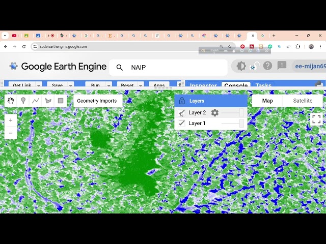
Visualizing NAIP Imagery and Monitoring NDVI Using Google Earth Engine | Step-by-Step Tutorial Want to analyze ...

9:00
Visualizing NAIP Imagery and Monitoring NDVI using Google Earth Engine

9 views

1 hour ago

Matt Forrest
The Death of the "GIS Analyst" (7 New Roles Replacing It)

The GIS Analyst job title is dying. As the modern geospatial stack explodes, that single catch-all role has shattered into 7 ...

14:24
The Death of the "GIS Analyst" (7 New Roles Replacing It)

927 views

1 day ago

Geo Bharat
FOSS4G Asia 2026 | Keynote: Open-Source Tools for AI-Powered Geospatial Analysis and Visualization

Presented by: Dr.Qiusheng Wu Title: Democratizing GeoAI: Open-Source Tools for AI-Powered Geospatial Analysis and ...

18:45
FOSS4G Asia 2026 | Keynote: Open-Source Tools for AI-Powered Geospatial Analysis and Visualization

393 views

2 days ago

Geospatial Analysis
How big is Brazil 🇧🇷.  The geography of Brazil
0:55
How big is Brazil 🇧🇷. The geography of Brazil

21 views

6 days ago

Geospatial Professional Network (formerly URISA)
Climate Vulnerability Index and Other Tools in Support of Community-Based Participatory Mapping

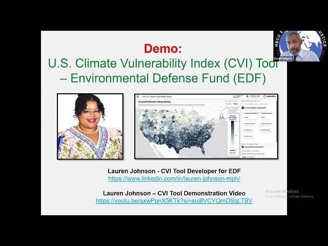
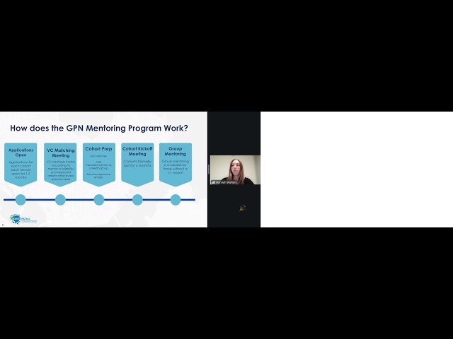
Climate Vulnerability Index (CVI) and Other Tools in Support of Community-Based Participatory Mapping Tuesday, February 10, ...

59:55
Climate Vulnerability Index and Other Tools in Support of Community-Based Participatory Mapping

29 views

2 days ago

GeoImpact Global
From Maps to Money: 3 Ways Geospatial Analysts Earn

Most people think geospatial analysts only make maps for reports or government offices. But GIS skills can do much more than ...

0:52
From Maps to Money: 3 Ways Geospatial Analysts Earn

0 views

4 days ago

Geojay GIS Solution
How to save your Model in ArcGIS Pro

... save model, GIS tutorial, geographic information systems, geospatial analysis, model management, data organization, ArcGIS, ...

2:02
How to save your Model in ArcGIS Pro

0 views

1 day ago

GIScience
Beginner Python in ArcGIS Pro Notebooks: Geospatial Data Analysis Skills  #Python #ArcGISPro #GIS

Learn Python for geospatial data analysis using ArcGIS Pro Notebooks (built on Jupyter notebooks)—a practical, job-relevant ...

1:09:10
Beginner Python in ArcGIS Pro Notebooks: Geospatial Data Analysis Skills #Python #ArcGISPro #GIS

83 views

1 day ago

Milan's Data Stories
Geospatial Data Science Essentials e-Book - Second Edition

Geospatial Data Science Essentials is a hands-on guide to geospatial analytics with Python. It distills 101 core concepts — from ...

6:43
Geospatial Data Science Essentials e-Book - Second Edition

90 views

3 days ago

AiTrive
Google Earth is AI Now!

Google Earth just took a massive leap forward — because it's no longer just a globe for pretty satellite views. With Earth AI and ...

6:27
Google Earth is AI Now!

633 views

5 days ago

ARNE.Technology
Accuracy vs Precision: What’s the Real Difference?

Accuracy and precision get used interchangeably all the time — but they are not the same thing. Many professionals casually treat ...

2:41
Accuracy vs Precision: What’s the Real Difference?

0 views

1 day ago

NASA Earth
NASA ASDC's Role in Advancing PREFIRE's Insights on Polar Radiation

... Harmony for data processing, and integration of AWS cloud with QGIS and ArcGIS Pro for advanced geospatial analysis.

1:31:22
NASA ASDC's Role in Advancing PREFIRE's Insights on Polar Radiation

46 views

1 day ago

Geospatial Analysis
Geography 314 - Lab Exercise 5 - Tutorial Video

0:00 - Introduction 9:45 - Exercise 5.1 19:41 - Exercise 5.2 30:46 - Exercise 5.3 45:33 - Exercise 5.4 55:30 - Exercise 5.5 56:06 ...

1:14:07
Geography 314 - Lab Exercise 5 - Tutorial Video

63 views

1 day ago

Geospatial Solution
Real time seismic risk assessment using QGIS and geospatial data

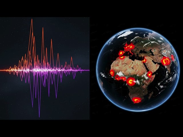
Earthquakes strike without warning — but what if we could understand their impact in real time? In this video, we demonstrate ...

5:38
Real time seismic risk assessment using QGIS and geospatial data

19 views

6 days ago

BJANALYTICS
How Geospatial Analysis Transforms Public Health Decision-Making

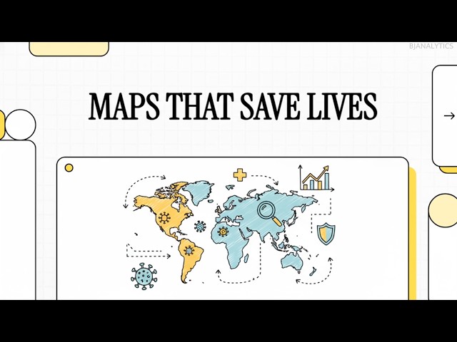
How do maps help predict outbreaks, identify health disparities, and guide life-saving decisions? This video introduces geospatial ...

5:39
How Geospatial Analysis Transforms Public Health Decision-Making

0 views

1 day ago

Ecospatial_lab
Shapefile Creation in ArcGIS  || Ecospatial Lab || #shapefile #arcgis #gis

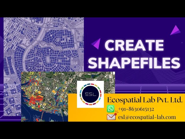
In this video, Ecospatial Lab demonstrates a step-by-step guide on Shapefile Creation in ArcGIS. Learn how to create, edit, and ...

46:05
Shapefile Creation in ArcGIS || Ecospatial Lab || #shapefile #arcgis #gis

25 views

7 days ago

Study Hacks-Institute of GIS & Remote Sensing
How to Make Map Layout in GIS || Map Layout in ArcMap || Create Map Layout in GIS

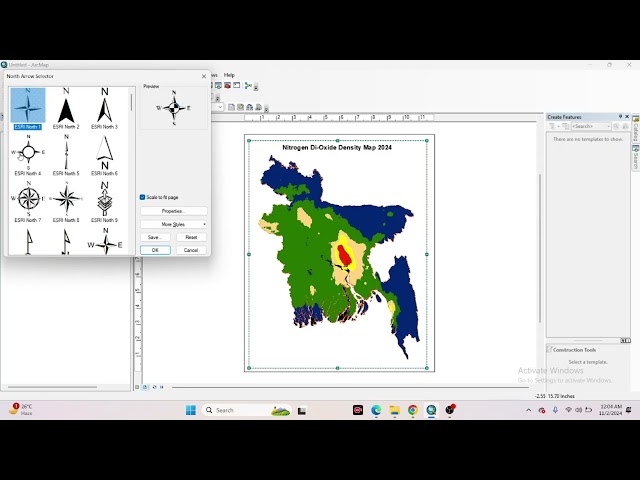
High-CTR YouTube Description (SEO + Engagement Optimized) **How to Make Map Layout in GIS | Map Layout in ArcMap ...

10:38
How to Make Map Layout in GIS || Map Layout in ArcMap || Create Map Layout in GIS

49 views

1 day ago

Geospatial Professional Network (formerly URISA)
GPN Member Meetup - Lightning Talks (February 10, 2026)

When: Tuesday, February 10 at 1 PM Eastern/12 PM Central/11 AM Mountain/10 AM Pacific We had a great response to the Call ...

58:57
GPN Member Meetup - Lightning Talks (February 10, 2026)

62 views

2 days ago

Study Hacks-Institute of GIS & Remote Sensing
How to Use Google Earth Engine in QGIS | Step-by-Step GEE Integration Tutorial

... and unlock powerful cloud-based geospatial analysis directly inside your desktop GIS? In this complete step-by-step tutorial, ...

40:56
How to Use Google Earth Engine in QGIS | Step-by-Step GEE Integration Tutorial

110 views

5 days ago