ViewTube

ViewTube
Sign inSign upSubscriptions
Filters

Upload date

Type

Duration

Sort by

Features

Reset

7,198 results

RS & GIS
ArcGIS Pro Full Beginner's Course (2025 Extended)

Ready to Master ArcGIS Pro? This ArcGIS Pro Tutorial is your Complete GIS Tutorial – 37 lessons in one awesome video!

2:04:33
ArcGIS Pro Full Beginner's Course (2025 Extended)

74,509 views

11 months ago

GIS & RS Solution
Split and Merge in ArcGIS Pro (Tutorial 6)

Hello everyone, I hope you are doing well. Welcome to sixth tutorial of ArcGIS Pro series in GIS & RS Solution youtube channel.

8:26
Split and Merge in ArcGIS Pro (Tutorial 6)

929 views

3 months ago

GIS Resources
Basics of Photogrammetry: Everything You Need to Know!

Photogrammetry is revolutionizing the way we capture and analyze spatial data! In this video, we break down the basics of ...

4:58
Basics of Photogrammetry: Everything You Need to Know!

16,374 views

11 months ago

Native GIS
Top 5 GIS Certifications for a Successful GIS Career in 2025

Is a GIS certification really worth your time and money in 2025? Choosing the wrong one can be a costly mistake that sets your ...

2:39
Top 5 GIS Certifications for a Successful GIS Career in 2025

2,760 views

7 months ago

Remote Sensing
How to Detect Minerals on Earth Using Free Hyperspectral Data & ENVI | Step-by-Step Tutorial

Learn how to unlock the secrets of the Earth using powerful remote sensing techniques! In this beginner-friendly tutorial, I'll guide ...

9:40
How to Detect Minerals on Earth Using Free Hyperspectral Data & ENVI | Step-by-Step Tutorial

2,921 views

9 months ago

RS & GIS FOR ALL
ArcSWAT | STEP 1| Installation Tutorial 2026 | Step-by-Step Guide for Beginners (Complete Setup)

In this video, you will learn ArcSWAT Installation in ArcGIS — Complete Step-by-Step Tutorial for Beginners. This is a full practical ...

6:22
ArcSWAT | STEP 1| Installation Tutorial 2026 | Step-by-Step Guide for Beginners (Complete Setup)

71 views

1 month ago

GIS & RS Solution
Google Earth Engine Tutorial 13: Accuracy Assessment (Overall, Users, Producers, Kappa Coefficient)

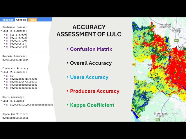
Hello everyone, welcome to @GISRSSolution I hope you are doing great. In this video, I demonstrated how to carry out accuracy ...

12:46
Google Earth Engine Tutorial 13: Accuracy Assessment (Overall, Users, Producers, Kappa Coefficient)

3,458 views

2 months ago

Native GIS
🔍 How GeoAI Works: The Future of Smart Mapping Explained

How does GeoAI actually work? In this video, we break down the fascinating workflow behind GeoAI (Geospatial Artificial ...

2:57
🔍 How GeoAI Works: The Future of Smart Mapping Explained

5,948 views

9 months ago

GIS & RS Made Easy
ArcGIS Pro Tutorial | Dissolve Tool | Merge Features by Attribute

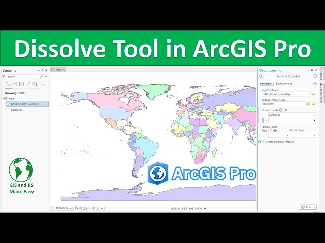
Learn how to use the Dissolve tool in ArcGIS Pro to simplify and merge adjacent features based on a shared attribute! 🗺️ This ...

4:44
ArcGIS Pro Tutorial | Dissolve Tool | Merge Features by Attribute

297 views

7 months ago

GIS & RS Made Easy
ArcGIS Pro Tutorial | Erase Tool

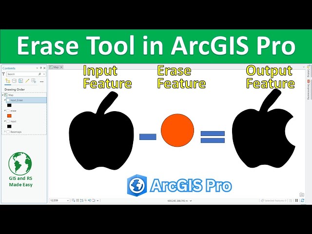
Learn how to use the Erase Tool in ArcGIS Pro to remove overlapping areas between feature layers. 🗺️ This step-by-step ...

1:41
ArcGIS Pro Tutorial | Erase Tool

118 views

7 months ago

Satellite Remote Sensing and GIS
Downloading OpenStreetMap GIS Data for Free: Step by Step

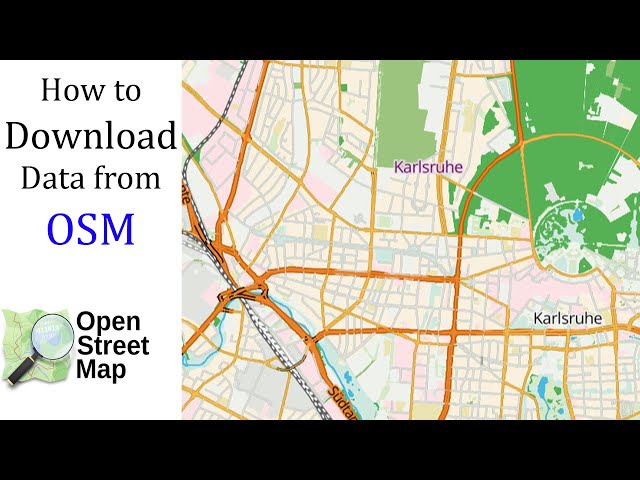
This tutorial will guide you through the steps to download data from OpenStreetMap for free. OpenStreetMap (commonly known as ...

14:57
Downloading OpenStreetMap GIS Data for Free: Step by Step

448 views

4 months ago

GIS & RS Made Easy
How to Use YOLO for Object Detection in Satellite Imagery | Beginners Tutorial

How to Use YOLO for Object Detection in Satellite Imagery | Beginners Tutorial Notebook: ...

31:43
How to Use YOLO for Object Detection in Satellite Imagery | Beginners Tutorial

1,864 views

7 months ago

GIS & RS Solution
Introduction to ArcGIS Pro: Interface, Tools & Navigation  (Tutorial 1)

Welcome to the ArcGIS Pro Tutorial Series by GIS & RS Solution! I'm excited to launch this brand-new tutorial series on ArcGIS ...

8:50
Introduction to ArcGIS Pro: Interface, Tools & Navigation (Tutorial 1)

1,784 views

5 months ago

GIS & RS Solution
Google Earth Engine Tutorial 15: Calculate Normalized Difference Water Index (NDWI)

NDWI is widely used for: Mapping surface water bodies, water resources management Monitoring floods and droughts ...

14:38
Google Earth Engine Tutorial 15: Calculate Normalized Difference Water Index (NDWI)

1,059 views

3 weeks ago

GIS & AI,GEOGRAPHY
Spatial Data & Their Management in GIS | GIS Tutorial @GISRS-1 #trending #gis

GISRS-1 Spatial Data & Their Management in GIS | GIS Tutorial Learn GIS step by step! In this video, we cover Spatial Data ...

7:33
Spatial Data & Their Management in GIS | GIS Tutorial @GISRS-1 #trending #gis

19 views

8 days ago

Study Hacks-Institute of GIS & Remote Sensing
Google Earth Engine Full Course (7 Days LIVE!)  Remote Sensing & GIS Masterclass

Check all details for the upcoming online training program from our website: ...

1:38:44
Google Earth Engine Full Course (7 Days LIVE!) Remote Sensing & GIS Masterclass

793 views

3 months ago

Study Hacks-Institute of GIS & Remote Sensing
How to use Google Earth Engine with ArcGIS Pro ? Step by Step Guide for Beginners

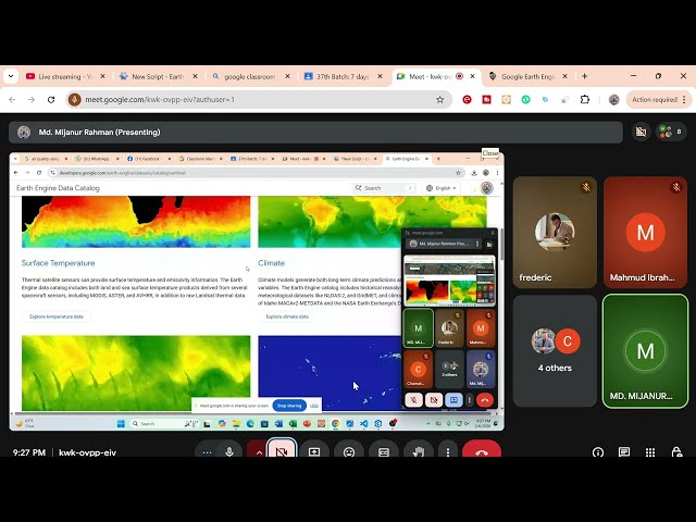
How to use Google Earth Engine with ArcGIS Pro | Step-by-Step Setup and Integration Want to use the power of Google Earth ...

17:42
How to use Google Earth Engine with ArcGIS Pro ? Step by Step Guide for Beginners

176 views

2 weeks ago

GIS & RS Made Easy
A Complete Beginner's Guide to ArcGIS Pro Part 1

Are you new to GIS and want to learn ArcGIS Pro from scratch? This complete beginner-friendly tutorial will help you understand ...

12:21
A Complete Beginner's Guide to ArcGIS Pro Part 1

91 views

13 days ago

GIS and RS Tutor
GIS tutorial

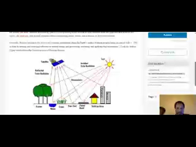
Introduction to Remote Sensing.

7:24
GIS tutorial

0 views

Streamed 4 months ago

Climate and RS & GIS Analysis
Hyperspectral (Hyperion ) remote sensing data download and visualization using ArcGIS and QGIS

Hyperion is a high resolution hyperspectral imager.

33:53
Hyperspectral (Hyperion ) remote sensing data download and visualization using ArcGIS and QGIS

96 views

1 month ago